
Diatremes in the Ku-ring-gai GeoRegion
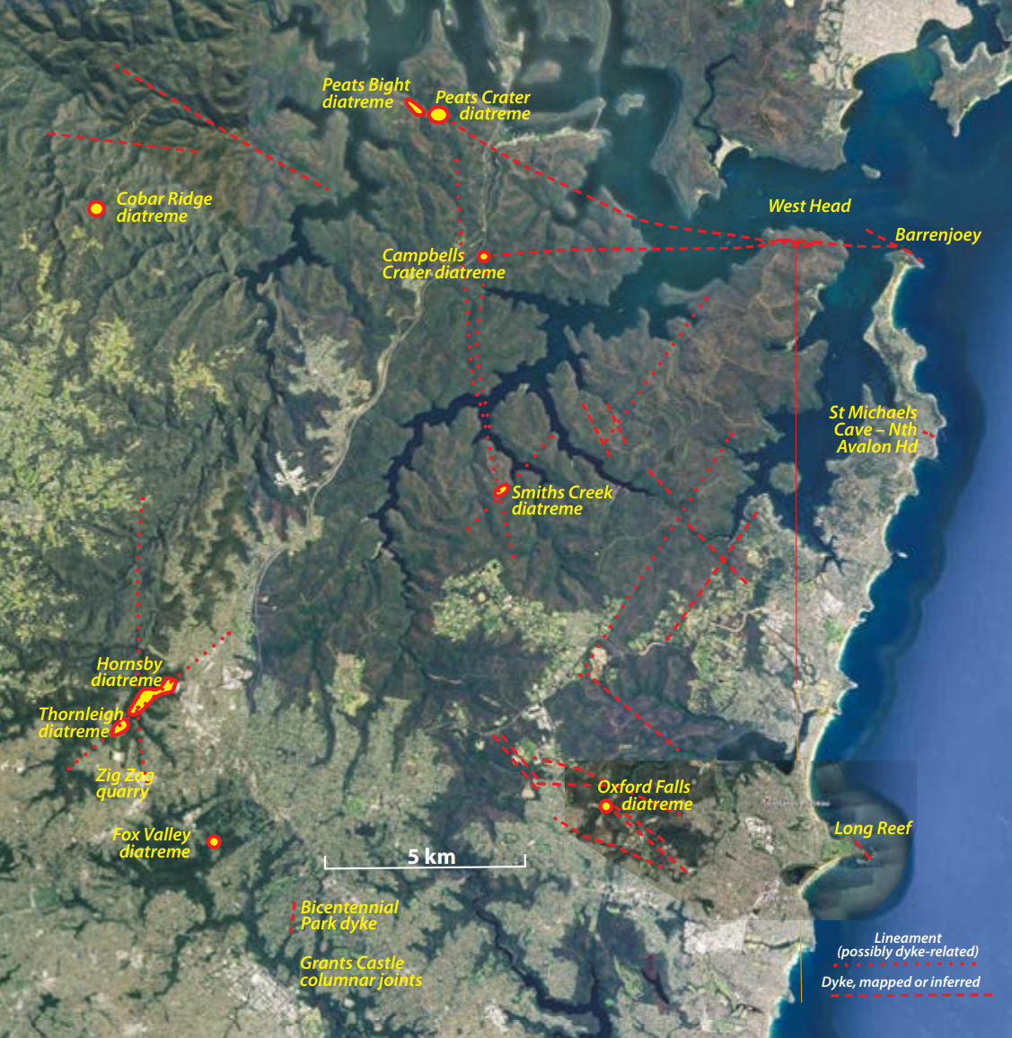
As the final sediments were being deposited in the Sydney Basin some 200 explosive volcanic vents erupted to the surface of the Jurassic landscape and blasted out shallow circular lakes or maars. These diatremes were filled with broken rock pumped from perhaps 20 km depth and then collapsed back on themselves bringing down debris from the land surface that is now preserved in the breccia as coalified wood.
Some of the world's best geological cross-section of a diatreme, along with deep semi-circular valleys can be found in the GeoRegion.
The number of diatremes in the GeoRegion is not precise, but let's say eight, but we don’t actually know how many overlapping vents make up the Hornsby body. The best guess is three in which case the total would actually be ten, but we can’t use that figure because it’s based on guesswork. The map extends to cover the Coba Ridge diatreme but that’s actually outside of the GeoRegion.
The map doesn’t highlight diatreme accessibility and this is very variable. Hornsby-Thornleigh will be strikingly good when the park eventually opens in the abandoned quarry, but much of its outcrop-free forested extent is highly accessible already from roads and walking tracks though its south-east flank is heavily built over with housing, parks and a sewage treatment works.
Fox Valley diatreme at Browns Field is also very accessible, almost the suburban backyard diatreme encroached by gardens and a sports oval. Surviving vegetation is warm temperate rainforest but soils are deep and any scattered weathered rock outcrops are restricted to creek lines.
Among the remaining ones, Peats Crater and Peats Bight are only accessible in Autumn when Muogamarra Nature Reserve is open to the public. Campbells Crater is overgrown and largely trackless, but you can enter from the Cowan to Brooklyn track beyond Jerusalem Bay. Smiths Creek is a scramble to get into and easier by boat. Oxford Falls is partly little used agricultural land and an extensive satellite communications base. Weathered volcanic breccia is only visible in one location but deep red clay soil is widespread.
Additional Information
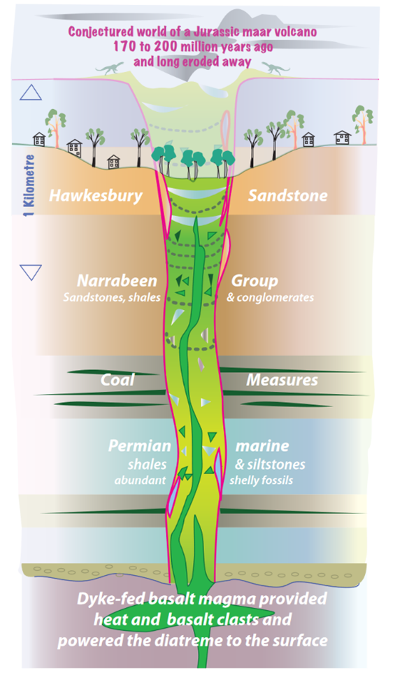 The word is Greek derived and means “through a hole or aperture.” The hole is what a diatreme makes when it punches its way through upper crustal rocks, driven by magmatic heat and powered by hot gases notably steam and probably also CO₂. Diatremes can have diameters or measurements easily hundreds of metres to more than a kilometre across. The Hornsby-Thornleigh system measures 2.6 km long by up to 500 metres wide though it incorporates more than one vent.
The gas-driven diatreme body consists of igneous rock fragments and pieces torn from its walls on route to the surface. It exploits fractures and weaknesses, creating a cylindrical or carrot shaped conduit.
The word is Greek derived and means “through a hole or aperture.” The hole is what a diatreme makes when it punches its way through upper crustal rocks, driven by magmatic heat and powered by hot gases notably steam and probably also CO₂. Diatremes can have diameters or measurements easily hundreds of metres to more than a kilometre across. The Hornsby-Thornleigh system measures 2.6 km long by up to 500 metres wide though it incorporates more than one vent.
The gas-driven diatreme body consists of igneous rock fragments and pieces torn from its walls on route to the surface. It exploits fractures and weaknesses, creating a cylindrical or carrot shaped conduit.
Reaching the surface it erupts spasmodically to form from a broad, shallow crater that can host intermittent lakes and is known by the German word “maar“ meaning mere or lake. The deposits in the pipe are often layered and show slumping and drag on the margins as the layers subside into magma-depleted space at depth. Large masses of rocks that have slumped from higher up in the diatreme pipe can also be found.
Kimberlite pipes are another example of a diatreme and these can bring ancient, deep-sourced diamond crystals from high pressure depths to the surface. The main driving gas in their case is CO₂, which is carbon sourced in the mantle just like the diamonds. More than 6000 kimberlite bodies have been identified in continental areas around the planet though only a small proportion carry diamonds.
The Sydney Basin is known to host at least 150 diatremes, and because their surface expressions are often subtle, more are still turning up; many encountered in coal mining and exploration. They are scattered across the central part of the basin but the densest cluster is in the north-west, to the east of Rylstone and south of Mt Coricudgy. The diatremes in the Sydney Basin probably represent the roots of maar volcanoes of Early to Middle Jurassic age, now eroded to many hundreds of metres or even kilometres below their original eruptive surfaces. Their deeply eroded basin landforms do sometimes resemble volcanic craters but in fact are erosional landscape forms in which rock outcrops are usually poor to absent rock outcrop is usually poor to absent.
Our understanding of their overall nature owes much to classic exposures in quarries like Hornsby and Minchinbury, or overseas examples like the Missouri Breaks. Minchinbury diatreme once formed a hill and the basalt agglomerate diatreme of Saddleback Mountain near Kiama stands tall against the faster weathering Broughton Formation volcanolithic and volcanic host terrain. It has roadside outcrops of mint-fresh agglomerate and its erosion level is deeper into the host stratigraphy than most local diatremes.
Jurassic Diatremes: Some useful references
Branagan, D.F., and Packham, G.H., 2000. Field Geology of New South Wales. 3rd Edition. New South Wales Department of Mineral Resources, Sydney.
Conroy, R.J. et al. (2022) The Natural and Cultural History of the Ku-ring-gai GeoRegion, New South Wales. Proceedings of the Linnean Society of New South Wales 144, 129-226.
Delpit, S., Ross, P. and Hearn, B.C., 2014. Deep-bedded ultramafic diatremes in the Missouri River Breaks volcanic field, Montana, USA: 1 km of syn-eruptive subsidence. Bulletin of Volcanology 76 (7); 1-27.
Herbert, C. and Helby, R. (Eds), 1980. A Guide to the Sydney Basin. Geological Survey of NSW Bulletin 26; 603pp.
Herbert, C., 1983. Geology of the Sydney Basin 1: 100 000 sheet 9130. New South Wales Department of Mineral Resources, Sydney.
Lorenz, V., 1975. Formation of phreatomagmatic maar-diatreme volcanoes and its relevance to kimberlite diatremes. Physics and Chemistry of the Earth, Vol. 9, 17–27. L.H. Ahrens, J.B. Dawson, A.R. Duncan, and A.J. Erlank (Eds). Pergamon Press, Oxford and New York.
Semeniuk TA. The Hornsby Quarry Geosite, NSW, Australia—A Geoheritage Treasure. Land. 2022; 11(12):2124. https://doi.org/10.3390/land11122124
White, J.D.L. and Ross, P., 2011. Maar-diatreme volcanoes: a review. Journal of Volcanology and Geothermal Research 201, 1–29.