
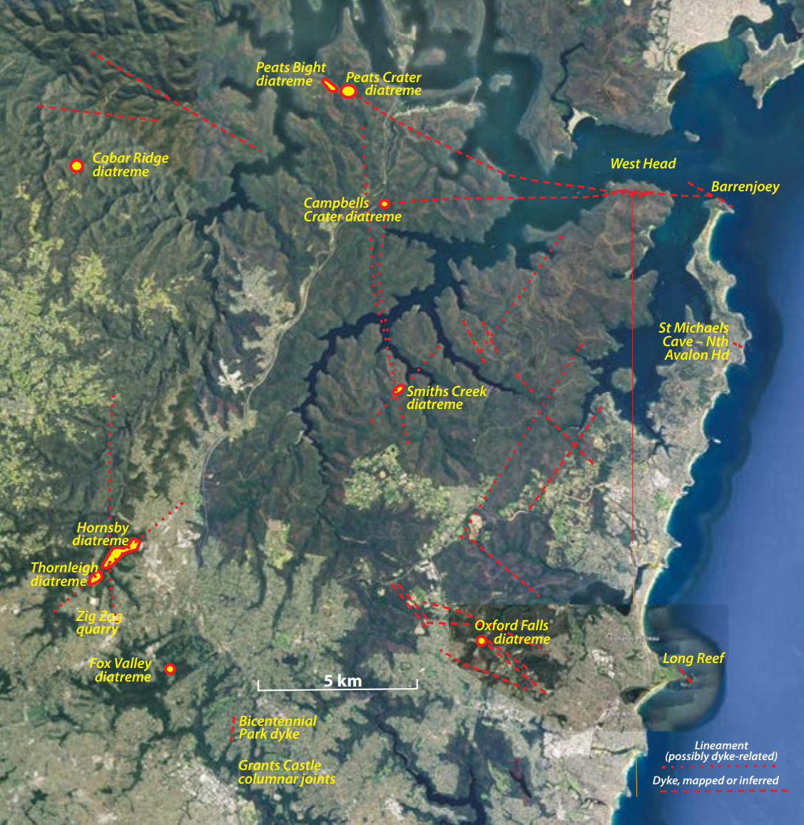
Sydney’s sedimentary sandstone and shale terrain hosts many igneous intrusions as narrow near vertical sheets (dykes) of basalt and dolerite of various ages, and gas-driven sub-circular vents (diatremes) that powered their way up through the strata in Jurassic times.
In geological usage dykes are vertical or near-vertical sheet like bodies of igneous rock filling fissures, fractures and faults that extended to magma sources at depth. Their igneous material can be of various compositions but the majority are of basalt or its more coarsely crystalline equivalent, dolerite.
In other places dykes can be composed of coarse-grained rock like gabbro or pegmatite and may carry ore minerals. Dykes can occasionally be of reactivated sedimentary, clastic or pyroclastic material, a local example being at St Michaels Cave, North Avalon.
The GeoRegion hosts numerous narrow, basaltic dykes, the Barrenjoey-West Head dyke widens to more than 14m and is one of the largest in Sydney Basin strata.
Published age dates of Sydney Basin dykes are highly variable, ranging from 51 to 225 Million years ago (Ma). Relationships of age to dyke direction are inconsistent, but dated ones with a broadly north-west orientation are entirely of Cretaceous (66-145 Ma) age. Long Reef shore platform exposes an alkali basalt dyke aligned that way and it is one of a number of dykes of similar alignment in the area. Dykes of east-west orientation, like the Barrenjoey-West Head system, tend to be Middle Jurassic in age 168-176 (Ma).
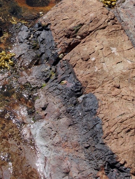
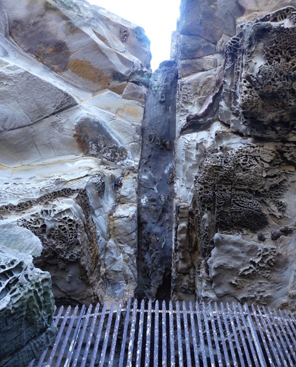
The permeable sandstones allow surface weathering processes to extend deep and most of Sydney’s dykes are altered to seams of kaolin which may erode quickly leaving narrow slots in the coastal cliffs and the sandstone landscapes. Fresh (unweathered) rock is only found on shore platforms where the rock is saturated or below groundwater level in a few quarries.
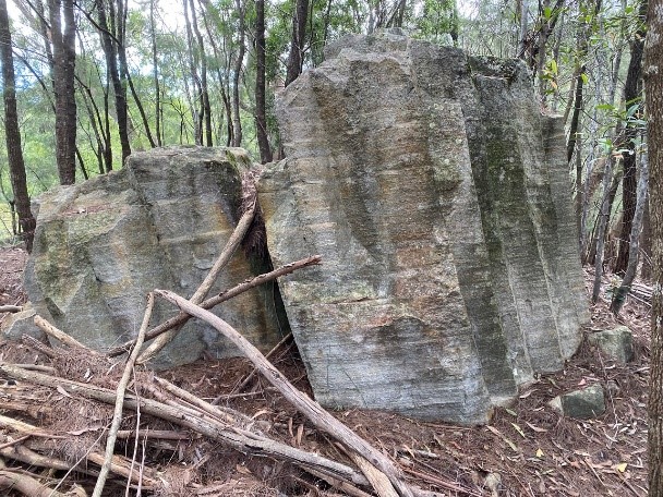
Dykes are injected into country rock as molten magma and have a slight baking effect on wall rocks. In sandstone this can result in formation of columnar cooling joints as seen at Grants Castle. These are similar to that formed in larger basalt flows or dolerite intrusions. More commonly the sandstone simply hardens to quartzite which was used in the past as construction aggregate and railway ballast, and was known as ‘white metal’.
Where dykes intrude shale or claystone a narrow edge of flinty baked rock can be formed. Known as hornfels this was sometimes used by Aboriginal people to make flaked tools. They also used the basalt for making ground edge axes (mogo).
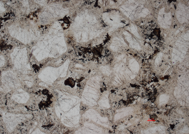
Tridymite, a high temperature form of silica was described in dyke walls at West Pymble and Bundeena but recent petrographic study of the West Pymble quartzite found only tiny needles of quartz.
Long Reef and Oxford Falls Dykes
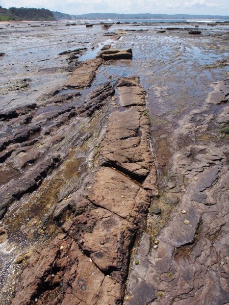
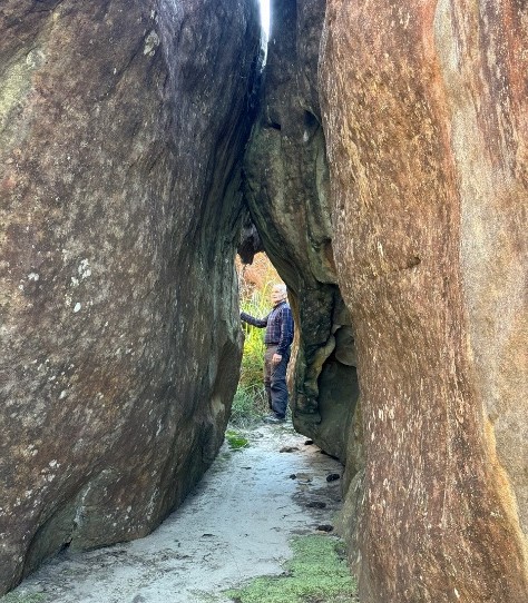
The Long Reef dyke is one of many north-west trending dykes in the Narrabeen-Oxford Falls area, which are apparent from lineaments crossing the sandstone bushland in the district. The Long Reef dyke cuts the Bald Hill Claystone in the middle of the Long Reef shore platform which shows it offset by small faults. Most Oxford Falls dykes were quarried for kaolin and ochre in the 1950s.
In places the dyke is seen to have baked the Bald Hill Claystone to a glassy texture and purplish black colour though a chilled margin to the dolerite isn’t clearly apparent. Thin section petrographic examination of the Long Reef dyke shows it to be a fine-grained, amygdaloidal alkali olivine basalt carrying olivine, titanaugite, plagioclase and brown hornblende.
In Garigal National Park, 7.5 km north-west of Long Reef and 3 km north of Oxford Falls, Google Earth images clearly show weathered dyke slots of north-west and east north-east orientations cutting a rock platform.
These are readily confirmed at ground level.
Between Long Reef and Barrenjoey, six dykes are mapped crossing the coast. Most are orientated north-west. In addition, there are three sea caves that may be eroded into dykes – Warriewood Blowhole, St Michaels Cave and The Ovens. Several major lineaments are visible crossing rock platforms that may be dyke channels from which all igneous rock has been eroded.
Photo: The north-west trending dyke slot north of Oxford Falls. Weathered dyke is buried beneath sand washed in from the sandstone.
Barrenjoey-West Head-Muogamarra Dyke system
It’s likely the dyke exposed on Barrenjoey’s north shore is the most significant in the Sydney Basin. It has a measurable outcrop width of 14 metres though borders and extensions are concealed by fallen sandstone blocks and shoreline debris.
It consists of a medium grained, banded, composite alkali dolerite anomalously rich in potassium and dated between 168 and 176 million years ago. (Embleton et al.,1985).
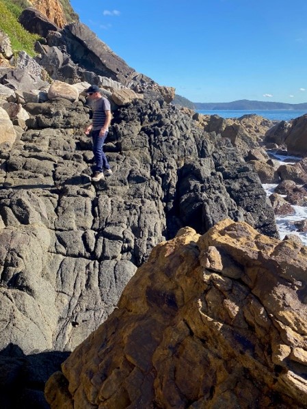
Its mineralogy consists dominantly of plagioclase and clinopyroxene with interstitial alkali feldpar. Part of the sample contains scattered amygdules filled by varying proportions of alkali feldspar and analcime, with local carbonate, chlorite, zeolite and biotite. Chlorite alteration is widespread through the rock. The relatively high potassium content is supported by portable XRF readings.
The dyke is projected across Pittwater to West Head in Ku-ring-gai Chase National Park where it swells to widths of several tens of metres with lobe-like offshoots (Martyn, 2018). It branches further westwards towards the diatreme of Campbells Crater near Cowan, and to the Peats Crater and Peats Bight diatremes, crossing the M1 marked by a deep slot in the road cutting.
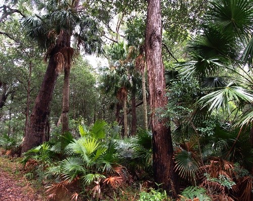
The distinctive flora of the West Head dyke
Roughly half of the twenty odd eucalypt species formally recorded in Ku-ring-gai Chase National Park can be found growing in West Head’s dolerite/sandstone terrain. These include grey ironbarks Eucalyptus paniculata, broad-leaved white mahoganies or bangalays E. umbra, Sydney peppermints E. piperita, and large-fruited red mahoganies E. scias.. Other tree species include Sydney red gums Angophora costata, turpentines Syncarpia glomulifera, cabbage tree palms Livistona australis and Allocasuarina species. A shrub layer is dominated in places by burrawang Macrozamia communis and grass tree Xanthorrhoea arborea thickets while rainforest margin species like Synoum glandulosum and Trema tomentosa grow in shady hollows.
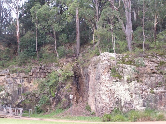
Bicentennial Park Dyke & Grants Castle, West Pymble
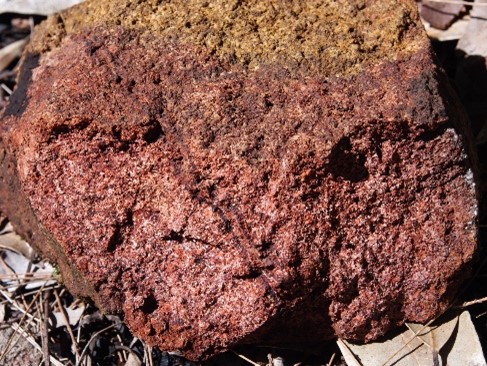
The cliff face bordering the east side of Lofberg Oval in West Pymble is a former quarry face that once yielded a hard, recrystallised form of Hawkesbury Sandstone, actually known as quartzite. The sandstone was hardened by the intrusion of a north north-east aligned basalt dyke, now deeply weathered but still exposed, tucked into a notch in the old quarry face.
Shows a closeup and microscope section of the quartzite, the latter featuring multiple tiny needles of quartz formed by recrystallisation.
Grants Castle is located roughly 1.3 km south of Bicentennial Park and doesn’t appear to have any surviving igneous body adjacent to it.
It’s assumed that the heat-source dyke or sill has been eroded away. It may well be related in time and origin to Bicentennial Park, but that’s an assumption.
St Michaels Cave Clastic Dyke
St Michaels Cave was formed by sea erosion along a vertical north-west trending clastic dyke that cuts Newport Formation of the Narrabeen Group. The host rock is mostly sandstone but with a thin, visible band of conglomerate. It has the transgressive nature of an igneous dyke but is composed of sedimentary rock debris with no indication of any igneous minerals. Shale clasts carry palynomorphs or fossil spores or pollen that’s recognised to be from the Wianamatta Group (Byrnes,1973), much younger than the host rocks of the dyke and long eroded away from above the site. The fact that such shale clasts have dropped by hundreds of metres from above is especially puzzling in view of a published opinion that the dyke may be a product of Jurassic diatreme activity.
The St Michaels cave dyke rock is relatively soft and quite crumbly and has collapsed and washed out to form a prominent cleft in the cliff face extending about 100m into the cliff. Rockfalls have buried the floor of the cave, once a sea cave whose true floor was only a few metres above present sea level.
For further Information regarding Igneous Dykes in Ku-ring-gai GeoRegion, click here.