Long Reef Geotrail
Important Safety Information
The Geotrail is 3 to 4km long depending the route taken. Allow about 3 hours and schedule the visit around low tide. During very high tides and storms, walking at the base of the cliffs can be difficult. Risks include uneven and slippery surfaces, sunburn and dehydration, unexpected waves, and falling rocks.
Please leave your dog at home and note that it is illegal to collect anything from the reserve.
Best to check the tides before you go at:
http://www.bom.gov.au/australia/tides/#!/nsw-sydney-fort-denison
Discover Long Reef and follow the Geotrail below.
Click here for a Long Reef Geotrail PDF to download

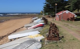
Geosite 1: Heritage Fisherman’s Hut
Directions
Long Reef Fisherman's Hut
Click here to view on Google Maps
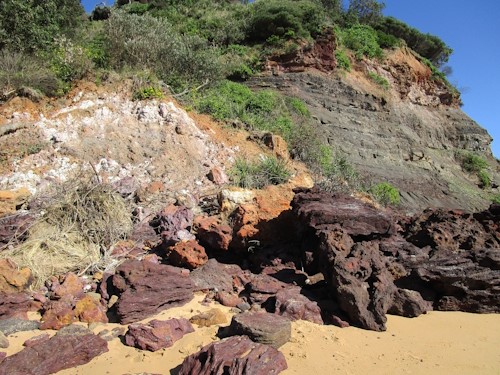
The geotrail begins at the eastern end of Fishermans Beach where the main sign is located near the red heritage hut.
This Geotrail within Long Reef Aquatic Reserve at Collaroy is one of several in the Ku-ring-gai GeoRegion established to interpret the geology and explain how the rocks influence the landscape and environment.

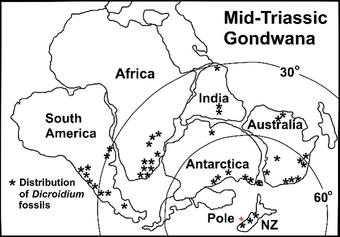
Long Reef is justly famous for the rich intertidal biology on the shore platform, but is less known as an important exposure of early to mid-Triassic sedimentary rocks, yet these provide the foundation for the plants and animals living here. The main rock sequence, once known as the ‘chocolate shales’ or the ‘Collaroy Claystone’, consists of fine grained, reddish-brown sediments deposited on the edge of Gondwana under a cold climate in rivers, lakes, and shallow marine environments about 245 million years ago. Today it is called the Bald Hill Claystone and the Newport Formation. The rocks contain a diversity of fossils that tell us about conditions on Earth shortly after the Permian extinction event when the swamp forests that formed the Illawarra and Newcastle coal measures were replaced by new plant communities that included Dicroidium seed ferns, lycopods such as Cyclomeia, and horsetails such as Neocalamites and Phyllotheca.
The sediments may have taken half a million years to accumulate and were intruded by an igneous dyke probably in the Jurassic. The beds are no longer horizontal but were bent and fractured when the crust stretched and the Tasman Sea opened between 84 and 52 million years ago.
In the claystone you can see; alleged fossil soils, numerous structural features (faults and folds), and rare copper minerals that hopeful prospectors once tried to mine. Variations in rock type and structure control the shape of the cliffs and shore platform and provide habitat for the rich intertidal fauna living here today.
History
The Aboriginal name of Long Reef is unknown. Lieutenant James Cook sailed past in HMS Endeavour in 1770 but was about 5km offshore and made no comment. Governor Phillip passed in 1788 and Lieutenant Bradley’s journal mentions ‘a reef of rocks which break some distance out’ but no name was recorded. The first written use of the name seems to have been in 1814.
In 1815 the headland and part of Dee Why Lagoon were granted to the Government boat builder William Cossar. He sold his 202ha to Matthew Bacon in 1822, then it passed to D’Arcy Wentworth formerly the principal surgeon, who almost immediately sold it to ex-convict James Jenkins. The Jenkins family used it for grazing until 1900, when it was bequeathed to the Salvation Army. In 1912 the State resumed 72ha to create Griffith Park.
At the end of Fishermans Beach a single historic hut is the last of several used by a small community of fishers from as early as 1872. In 1917, some 30 people lived here in 16 dwellings (including tents) and Council began charging rent and required the occupants to improve sanitation. As leases expired, huts were demolished, this last one is now managed by the Long Reef Fishermen’s Association.
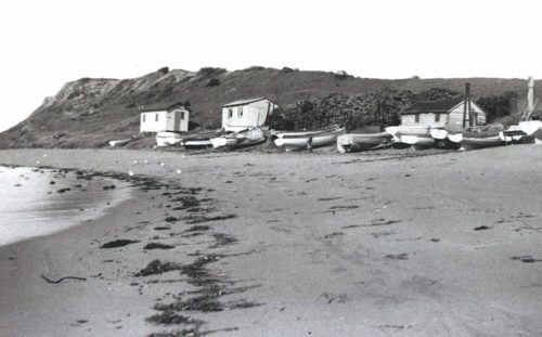 Photo: Fisher’s huts in about 1937. Northern Beaches Council Library, Local Studies 40032
In 1997 the expansion of exotic plants including large clumps of Agave americana led eight locals under the guidance of Peter Miller to form ‘Reefcare’ and begin bush regeneration.
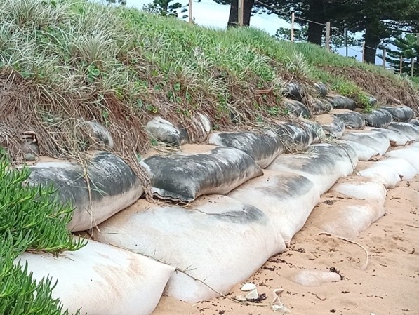
Sand on Fishermans Beach has a brownish orange colour, is coarse, and contains a high proportion of rounded and platy shell fragments and granules of local bedrock. The beach is narrower and steeper than others and has been subject to severe erosion.
Geobags were installed after storms in 2016 which eroded the beach to the edge of the car park. This is a ‘softer’ engineering solution to coastal erosion than concrete or rock sea walls and the bags have an effective life of at least 25 years. Two or three decades from now it is expected that sea level will be 20-30cm higher and when that is added to storm waves and a king tide it will make quite a difference in the level of wave run up. Whether this level of protection will be enough, is a question that is yet to be answered.
More than 140 species of birds have been recorded at Long Reef including at least 40 threatened species. Of particular note are sooty oystercatchers, osprey, sea eagles, Australasian gannets, terns, cormorants and silver gulls. As well as migratory species such as double-banded plovers from New Zealand, and short tailed shearwaters from the margins of the Arctic. When many birds arrive or are preparing for migration, please do not disturb them.
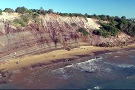
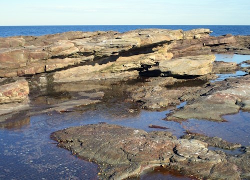
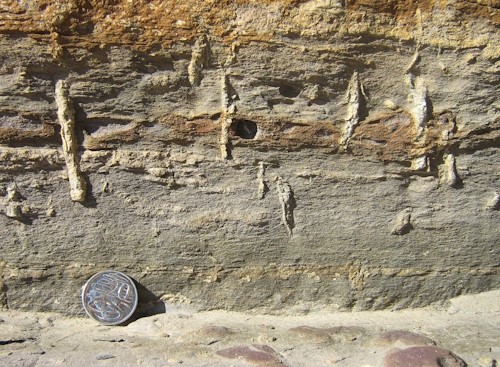
Geosite 2 - Cliff Line & Land Slip
Claystone beds and thin conglomerates in this section of the cliffs dip (slope) toward the fold at Geosite 3 and multiple layers of alleged fossil soil are exposed. Sedimentary beds in this section are disrupted by several faults each with limited displacement. The fault planes often have polished faces that show the relative direction of movement, or are layered in iron oxides deposited by groundwater.
Jointing in the claystone is readily visible in the cliff and in grid patterns on the shore platform. These fracture planes were caused by the rock adjusting to stress as they were folded and deformed and may be linked to the opening of the Tasman Sea along a now extinct mid-ocean ridge between 84 and 52 million years ago.
The claystone is almost entirely composed of iron oxide and kaolin clay. Coarser beds within it contain pebbles that have a volcanic origin that may have come from a vanished landscape offshore.
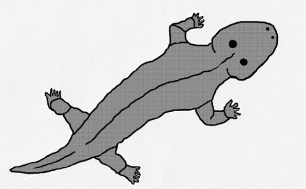
Many trace fossils are present but not easy to find. The partial fossil of a primitive amphibian estimated to be 3m long was recovered here and named Bulgosuchus gargantua. The name implies that it was found in the Bulgo Sandstone but in fact it came from the Bald Hill Claystone. Today most amphibians are found in freshwater and if this was true in the Triassic then this evidence may conflict with the marine environment suggested by other fossils in these beds.
What did Bulgosuchus look like? A difficult question as only a lower jawbone was found, but by comparing it with fossils of the same age from other places it was a short, wide crocodile like creature with a large, broad, head. Not a reptile, and strictly not an amphibian, but a top predator in its time.
Photo: Sketch of a ‘giant’ temnospondyl Bulgosuchus gargantua known only from Long Reef.
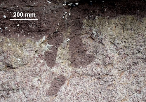
Common trace fossils include inclined burrows about 250mm across informally named Turimettichnus sp. The rough exterior is the inside surface of a filled burrow and the linear marks are claw scrapes made by the organism that lived there in Triassic times. The nature of the animal is uncertain as only one poorly preserved body fossil has ever been found. It is thought to be a crustacean rather like a lobster. This is part of the evidence that at least some of the Bald Hill Claystone was deposited in shallow marine conditions. The best exposure of these burrows is sometimes covered by sand.
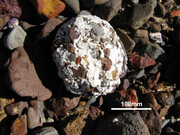
Near the western end of the cliff closer to the fisherman’s hut, the higher parts of the claystone are weathered to white kaolin clay which is subject to land slips. The large slip has been moving for at least 15 years and is reactivated every time storm waves cut the base of the cliff or when exceptional rainfall occurs.
Photo: Inclined and infilled burrow of Turimettichnus sp.
The white clay is remarkably smooth and may have been used by Aboriginal people as a pigment. When the slump is being eroded by waves, balls of clay roll back and forth on the beach and collect sand and pebbles. The technical name for these unusual forms is ‘armoured mud balls’.
This cliff also fails on a smaller scale more or less constantly because the mudstone is subject to shrink and swell through wetting and drying cycles. In dry weather it fractures into small particles that form cones of debris that are washed away when the waves reach them. In wet weather it flows as a muddy red-brown slurry.
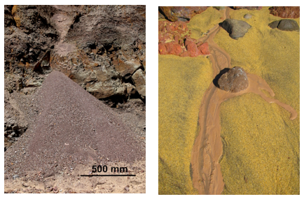 Debris cones and slurry flow.
Geosite 3 – Synclinal Fold in the Bald Hill Claytone
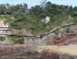
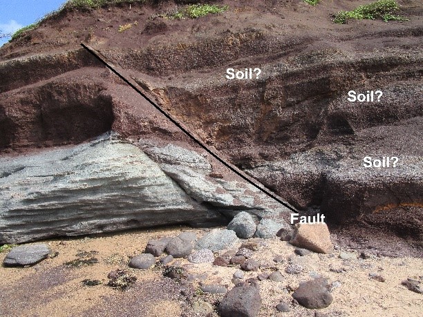
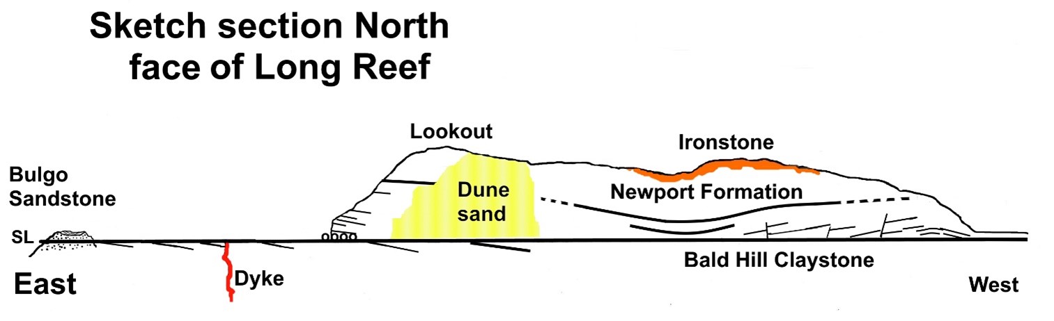
At Geosite 3 the rocks in the cliff face are gently folded into a syncline (a downward warp). Several small faults are visible where individual beds are displaced vertically. Structures like this remind us that our conventional view of the rocks in Sydney as a horizontal layered sequence is inaccurate. The paler layers in the Bald Hill Claystone are thought to be soil horizons formed in Triassic times and now fossilised (see also Geosite 6). The base of the Newport Formation can be conveniently placed at the bottom of the prominent sandstone bed. Most interpretations of Sydney’s coastal geology would place the Garie Formation at this level, but it has not been confirmed on Long Reef.
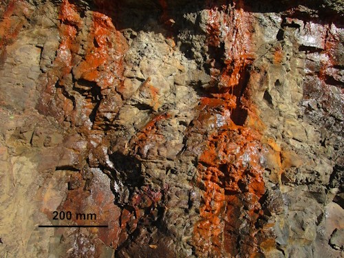
At the lowest point of the fold several water seepages depositing bright orange stains of iron oxide drain groundwater held in the rocks. The flow rate is low but these springs could have been a source of freshwater for Aboriginal people.
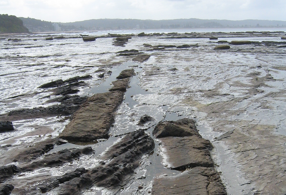
The shore platform is quite wide and covered by Neptunes’s necklace (Hormosira banksii), a seaweed that effectively protects the rock surface from erosion. The most important process of platform formation is wetting and drying of the soft rock through every tide cycle. As the rocks dry out, they fret and spall, and the process ceases when saturated rock is exposed thus forming an almost level surface.
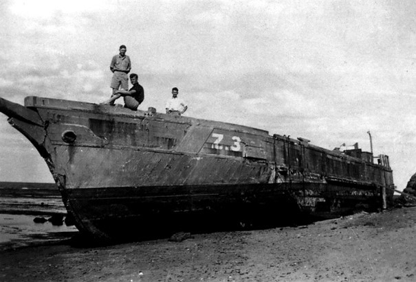
Long Reef Point and surrounding waters have a long history of shipwrecks beginning in 1816. More than 24 ships have been wrecked here including five coastal colliers, Mountain Maid 1868, Susannah Cuthbert 1875, Duckenfield 1889, Euroka 1913, and Myola 1919. At least eleven lives were lost in these events. In 1942 with war raging, a fleet of coastal traders was assembled in New Zealand by the US Army Small Ships Section. This included the wooden auxiliary ketch Altair (S117), and the fleet crossed the Tasman. Altair, built in 1903, had been engaged in collecting sand and gravel from Northland’s beaches for concrete making. Her shallow draft was attractive to the Army for delivering war material into coastal waters around New Guinea but she ran aground here in October 1942 and was never re-floated.
Photo: Wreck of the Altair in 1942, at Geosite 3 (Photo from NBC Library, Local Studies 41680).
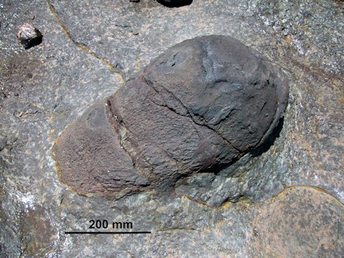
On the edge of the shore platform near the fold, large boulders of ironstone have fallen from the top of the cliffs. These are very honeycombed and contain blocks of white sandstone, and traces of sedimentary bedding essentially the same as other Triassic rocks in the cliff. This same material can be seen at Geosite 8.
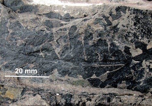
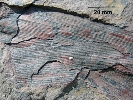
Adjacent sandstone boulders contain trace fossils on their bedding planes and sub-vertical infilled tubes cutting through the bedding. Various informal scientific names have been given to these burrows but it is not easy to distinguish one from another. They can be classified by size and shape but without finding a preserved organism it is not certain what made them. Worms are often nominated, but there may be other explanations. The surface of the bedding planes reveal tracks, trails, and faecal pellets (coprolites). Some were deposited by fish and analysis shows that they are rich in phosphorous and carbon which is characteristic of vertebrate predators. Other components include; fish scales, insect remains, and plant fragments, all suggesting a diverse environment that may have been either fresh water or marine. Fragmentary leaf fossils and small logs converted to coal may be found in finer grained rocks.
Vertical burrows of an unknown organism.
Fossil faecal pellets and sundry feeding trails, unknown species.
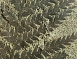
Dicroidium sp. A Triassic seed fern
Phyllotheca sp. A Triassic horsetail
To the east of the synclinal fold a 160m length of vegetated cliff collapsed in a series of landslides on the 8th and 9th of March 2022 when the soil was saturated by 315mm of rain. The toe of the slide is being removed by waves, the lower part of the cliff face will become steeper, and new slides will occur. The estimated volume of debris involved in this event was 3,000m3 and the cliff retreated by 1 to 2m. Older debris from an earlier landslip is buried by the recent material.
Continue walking toward the Point and Geosite 4 along a black sand beach.
This black sand beach contains a large proportion of ‘heavy minerals’ such as ilmenite (iron titanium oxide) and magnetite (magnetic iron oxide). Both minerals are denser than quartz or shell fragments and resistant to weathering. They are derived from the claystone and have been concentrated on the beach by wave action and the wind moving lighter fractions into the dune that climbs the headland.
Geosite 4 - Boulder Beach & Black Sand Beach
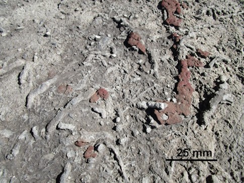
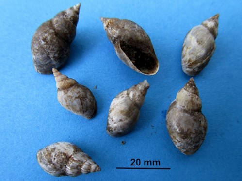
The track leaves the black sand beach at the beginning of a boulder beach and beneath the track surface there is an Aboriginal shell midden buried by sand. Little of the deposit is visible and as an Aboriginal site it should not be disturbed. It consists of broken shell (nerites, abalone, cartrut shell and others), charcoal, and a few stone flakes. It is neither large nor old, perhaps a few hundred years, and given the richness of the food supply in the intertidal zone it is suprisingly small.
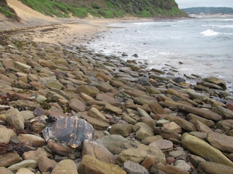
Photo: The largest brown ‘boulder’ is a 2m long upper-shell (carapace) of a leatherback turtle (Caretta caretta) that washed ashore in 2004.
In the boulder beach large plate-shaped boulders lie against one another, overlap and slope seaward. During average storms these boulders jostle together and during extreme northeast storms they can move. The boulders extend 2m above the highest observed wave attack, and they may have been placed by storms larger than any experienced to date, or perhaps their position relates to a recent period of higher sea level. Several different rock types are present, including occasional lumps of coal from historic shipwrecks in the bay and basalt from the dyke.
Soil conditions on the headland are harsh. The profile is a thin mantle of dune sand over weathered rock with high salt content and limited water storage. The original vegetation would have been a coastal grassland of kangaroo grass (Themeda triandra), which is now listed as an endangered ecological community. In the 20th Century the slope was heavily eroded and used by children for ‘sand hill surfing’ on sheets of cardboard. It was invaded by boneseed or bitou bush (Osteospermum moniliferum), a native of coastal South Africa, that was widely used to stabilise sand dunes in the 1970s. The headland is now undergoing restoration by Reefcare.
Move onto the edge of the shore platform toward Geosite 5. Note that the features here are not accessible at high tide.
Geosite 5 - The Rock ‘Island’
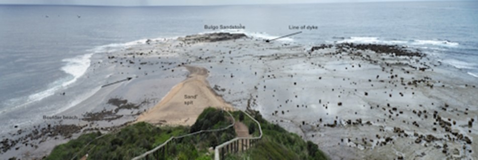
Geosite 5 is the rock ‘island’ on the end of Long Reef Point. You can visit it for a couple of hours before and after low tide and as you cross the shore platform you will find a linear igneous dyke about 1m wide trending northwest.
The dyke is a vertical sheet of basaltic rock that intruded all the sedimentary strata as a molten magma, baking and hardening the margins (contact metamorphism). The alignment of the dyke is offset several times but the offsets do not appear to be on fault planes. The centre of the dyke is less weathered rock and contains vesicles (bubble holes) and plate shaped minerals aligned parallel to the dyke walls. It is probably of Jurassic age (about 160 million years ago) and the rock may have been used by Aboriginal people as raw material for making ground-edge axes (known as mogo).
Dyke
Halo of gastropods around a boulder
The large boulders scattered across the platform can move during extreme storms and at other times they protect clusters of shellfish. Small hollows and gutters on the platform are occupied by many other invertebrates.
Viewed from the sea at high tide, this part of the shore platform can look like an open passage and a number of small boats have come to grief in these shallows.
The sandstone ‘island’ is the oldest rock exposed on Long Reef. The feature is a favoured roost for seabirds and their faeces encourage a growth of orange and grey-green lichens on the highest and driest parts of the outcrop.
In cross section the outcrop is lenticular and individual beds are cross-bedded, both properties indicating that this sandstone was deposited in a stream channel. It is quartz lithic sandstone with a mineral composition unlike the claystone and has been mapped as Bulgo Sandstone which lies below the Bald Hill Claystone. However, this outcrop may have been misidentified on the geology map as exploratory drilling on Turimetta Head to the north, indicated that the Bulgo Sandstone should be deeper.
At the seaward edge of the outcrop a vertical zoning of intertidal organisms can be seen on the rocks and is attributed to different conditions of exposure to tides and wave splash. Inundation is important in understanding this pattern but so too are the conditions of the rock surface and the varied cracks and crevices formed by joint and bedding planes. At the lowest tide and with little wave action, you may see hundreds of sea urchins (Heliocidaris erythrogramma) living in burrows that they have excavated into the rock.
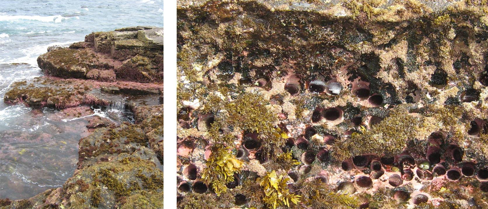
Vertical zoning in marine organisms as seen at low tide and sea urchin burrows.
Geosite 6 – Faulted Fossil Soils at the back of the Sand Spit
In the cliff face at the back of the sand spit multiple pale coloured layers in the claystone have been described as fossil soils (palaeosols) of Triassic age. The sequence is referred to as the Long Reef palaeosol series allegedly composed of grey brown podzolic soil profiles which supported a coniferous forest.
The paler layers have been described as bleached topsoils over red-brown subsoils. Various lines of evidence such as texture change, supposed traces of soil structure, fossil root traces, and preserved plant remains are claimed to support this interpretation. Although the palaeosol literature is extensive, this interpretation has been questioned and other studies favour a shallow marine environment for deposition of these sediments rather than a terrestrial one.
A point in favour of the sediment being deposited in marine or estuarine conditions is that burrows of the lobster like Turimettichnus are common as subcircular or dumbbell shaped traces on the shore platform and as near vertical filled tubes that penetrate the ‘soil’. Other strong colour mottles in these beds appear to be various forms of infilled invertebrate burrows.
Turimettichnus burrow cutting the fossil soil.
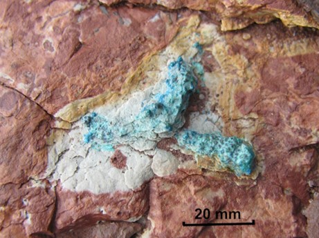
Atacamite copper mineral.
Somewhere along this southern cliff face there was an attempt to locate copper ore when a tunnel was driven into the cliff probably between 1903-1911. Little is known about this prospecting venture and no sign of the workings remain. The only clue to the presence of copper being rare blobs of bright green minerals (copper chlorides) in the mudstone that can be seen on the shore platform. You may need to search diligently!
At this point you may climb the path to the lookout at Geosite 7 or walk along the beach on the southern face of Long Reef toward Geosite 8 which will give you another perspective on the sequence along the north side. Dune sand is barely present, the downward fold is there but difficult to identify, and several small faults with polished surfaces (slickensides) can be seen.
Geosite 7 - View of Long Reef Point
View of Long Reef Point from the Lookout at mid to high tide.
The wide section of the shore platform below the lookout is formed on the relatively soft rocks by a combination of wave erosion and water layer weathering. Waves adjust to the shape of the point and usually break parallel to the shore on both sides. Wave energy is concentrated at the point where erosion rates are rapid and the widest shore platform forms. Most of the shore platform is exposed at low tide and the rock surface is planed almost level by water layer weathering. The sand spit changes shape frequently depending on wave conditions and even the largest boulders on the platform can shift during major storms.
Looking south, the next headland is Dee Why Head which has quite a different shape and only a narrow shore platform. It is formed on Hawkesbury Sandstone which is the younger rock unit above the Newport Formation. Some researchers have speculated that a fault may explain this apparent disjunct in the geology between Long Reef and Dee Why Head but with the Long Reef rocks dipping (sloping) at about 4o to the south that alone is sufficient to explain the difference.
Proceed west down the path on the south side of the golf course past various sculptures and return to the beach on the boardwalk at Geosite 8.
Geosite 8 - Either side of the Boardwalk ramp
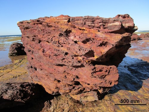
To the east (toward the Point) a rugged outcrop of bright red rock extends onto the beach. This has been described as a ‘laterite’ allegedly of Miocene age (about 17 million years ago). The word ‘laterite’ usually carries assumptions about the material having been formed as a soil in a warm humid climate. This outcrop does not have the supposed characteristic physical properties of a laterite profile and it is capped by a thin layer of very young dune sand that some researchers have described as an integral part of the ancient profile.
The red rock is the same as the boulders seen at Geosite 3 and therefore needs to be considered as a weathered version of a Triassic unit that is conformable with the rest of the sequence. That does not explain what it is, or how it formed, but it is a lead to finding answers. Meanwhile, it remains a geological puzzle.
‘laterite’ outcrop
Peat outcrop on the creek bank
Sub-fossil freshwater snails
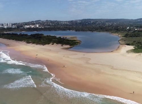
Dee Why Lagoon and Long Reef Beach
To the west of the boardwalk ramp on either side of the creek, a layer of muddy peat overlying a sticky grey clay outcrops beneath the dune sand. The peat contains pollen from; sedges, she-oak, eucalyptus, and tea-tree. Sub-fossil snails found in the peat bed are either Glyptophysa or Isidorella sp. The pollen and the snails indicate that the peat accumulated in a freshwater pond or swamp, and it has been carbon dated as 3,980 +/- 150 years old, suggesting a changed coastline and/or a different recent sea level.
Further west Long Reef Beach fronts Dee Why Lagoon, which was formed when the beach and foredune closed the mouth of Dee Why Creek about 7,000 years ago when sea level reached its present position. During the last Ice Age (about 20,000 years ago), sea level was 120m lower than present and Dee Why Creek would have run in a valley out to a shoreline perhaps 10km offshore. Beneath the present beach the bedrock valley is approximately 50m deep. It is the nature of small coastal lagoons that they will gradually fill with marine sediment washing inshore, and terrestrial sediment delivered from the catchment. Dee Why Lagoon is a very shallow, non-tidal ICOL (intermittently closed and open lagoon), and can sometimes drain almost completely exposing a mud bed.
Sand on this beach and in the dunes is nearly all quartz which is quite different from other beaches seen on the Geotrail. The main source is weathered Hawkesbury Sandstone found in the catchment.
The lagoon has been subject to recent change and little of its present appearance is ‘natural’. During the ‘Dandenong Storm’ of 1876 the dunes fronting the lagoon moved inland leaving high water mark survey lines in the present surf zone. The storm was named after the sinking of the SS Dandenong off Jervis Bay with the loss of 43 lives and should not be confused with another big storm in the Dandenong Ranges in Victoria in 2021. In the 1940s the dunes were flattened and quarried for defence purposes, and it was not until the mid-1970s that any dune stabilisation work and later bush restoration was attempted.
It may be concluded that although a lot is known about Long Reef Headland, there are many knowledge gaps. The good news is that anyone with critical powers of observation can make new discoveries. For example, Antonio Rajaratnam, was awarded Young Scientist of the Year 2020, by the Science Teachers Association of NSW for rediscovering the sand fairy cicada (Sylphoides arenaria) and working out its life cycle in this rather messed up area of dune sand, after it had been locally ‘missing’, presumed extinct, for a century.
What other secrets are hidden on Long Reef or indeed in the Ku-ring-gai GeoRegion? Perhaps other nature lovers will make similar discoveries as they experience the wonders visible along the Long Reef Geotrail.
REFERENCES
Click here to view Long Reef references PDF for further reading.